record and upload

Record georeferenced video from a variety of platforms including dashcams, drones and helicopters. Or use our free smartphone apps on Android and iOS.

save to the cloud

We securely store your data in your own branded video content management system that is hosted by us on servers located across the globe.

View and analyse

Easily search and view your videos. Our built in tools allow you to stream and analyse video alongside your spatial data using only your web browser.

Machine Vision

Beautifully simple machine vision models. Choose from our library of pre-built machine learning models to search for and locate objects in your videos.

View your data how you want!

RouteShoot is designed so that the data you collect is completely open for you to use as you need.

We use standard protocols wherever possible such as OGC WFS/WMS so that you can integrate routes and detections dynamically with your own systems.

So, whether it is condition data or asset inventory, you can plot and analyse your Machine Learning output as you want.

How does it work?

RouteShoot is a complete web based solution for handling and managing all your georeferenced video content. Our platform stores and presents your location based video making it easy to view, analyse and share data across your organisation.

RouteShoot ML is an extension to RouteShoot that allows you to process any of your videos using our state of the art ML detection algorithms. We have detection models that allow you to collect information automatically on street furniture, road markings and road condition. With an intuitive and incredibly simple user interface you can take full control of your data collection using a fully “self service” approach from collecting the video to processing the imagery.

Choose the perfect plan

RouteShoot is available as a subscription service with all the software and services delivered through your web browser. We have a subscription plan to suit most users but if you have a specific need please do contact us for a bespoke package.

Personal

£95

Per month*

Team

£POA

Per USEr/month

Corporate

£POA

Per user/month

Frequently asked questions

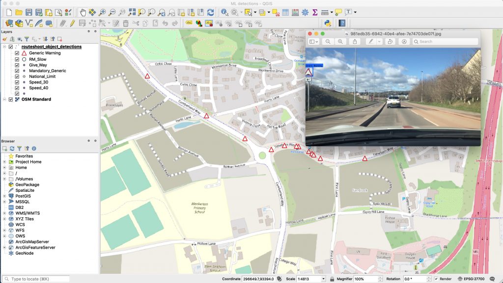
Georeferenced or geotagged video has an associated geographical element, for example a route. Georeferenced video gives you the benefit of being able to see the exact location a video frame was taken as well as the date and time. Having this additional data can be beneficial in identifying asset locations, evidence of changes, works completed or simply as a survey history. RouteShoot’s georeferenced video content management system allows you to catalog and search your video files spatially, allowing you to find a particular video quickly and easily.

Machine Learning refers to computer algorithms that learn through experience. In much the same way as a human brain works, machine learning improves through experience. Broadly speaking the more it learns the better it will become at making predictions. Object detection is a specific type of Machine Learning that uses images to train the models. Objects such as signs, cars and road markings etc are categorised in a series of training images and used as a training set to build a detection model. RouteShoot uses these models to process videos.

How accurate a model is depends on a number of factors; how many images in the training data, how well are the objects classified in these images, how long was the model trained for etc. No model will ever be 100% accurate but in many cases it may well be more accurate than a person classifying the same data set. However, RouteShoot uses an innovative approach to ensure the quality of the data.

Our customers have collected many thousands of route based videos over the years. In most cases these videos have been used for tracking network condition and defects. Whilst this data is extremely useful as a visual record in its own right, we thought it would be a great idea to make even more use of it. The vast majority of our customers have struggled with the quality of highway asset records so we took the opportunity to build Machine Learning tools into RouteShoot to solve this problem. Using ML together with these large libraries of video data is an obvious next step for RouteShoot.

No problem! We can produce bespoke models to suit your needs and can typically have a detection model up and running in only a few days. Please do contact us with your requirements so we can discuss how we can help you.

Absolutely! At RouteShoot we are specialists in systems integration and can provide you with an integration solution using our APIs. We are also business partners with one of the UKs leading Asset Management System suppliers – Confirm by precisely.com. By using the Confirm/RouteShoot module we are able to offer a solid integration option that is fully supported by both Precisely and RouteShoot.  

Our award winning platform deals with everything, from creating geotagged videos, to playing them back in our map based video content management system. Contact Us

Our clients say

"RouteShoot has enabled our business to add value to our Design Team resource, sharing and promoting our detailed scheme improvement proposals for the Roads Programme with other teams quickly and easily"
David Johns
Highway Engineer
"RouteShoot has proven to be a great asset in planning our Winter Maintenance operations, it has helped us to optimise the routes thereby reducing costs and using the videos for training purposes we have been able to improve driver interoperability"
Gary Nash
Project Manager
"RouteShoot is scaleable and cost effective providing a real solution in shorter timeframes, consequently the Philippines Goverment have now mandated its use for their new roads financing program - Kalsada"
Kai Kaiser
Senior Economist
"RouteShoot's ease of use, accurate and effective search functionality has been extremely beneficial to both Premier and its clients. The ability to email a link to the videos to anyone with an internet connection has been just awesome and blows our clients away."
Chris Bartlett
Director of Technology